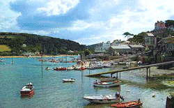
Salcombe Pilot Notes & Charts
Pilot notes are meant as a general guide, or for use in conjunction with a Pilot book or chart.
Salcombe Harbour Chart - NOT TO BE USED FOR NAVIGATION
Unauthorised reproduction strictly prohibited - Terms & Conditions
Salcombe is primarily a recreational and leisure harbour which can normally accept vessels up to 30m LOA, 5.5m draught and 100 tonnes displacement but has on occasion hosted larger vessels up to 50m length and 600 tonnes displacement by prior arrangement, usually out of season when the harbour is quiet.
For entrance to the harbour, visitors are encouraged to obtain navigational information available from official publications eg Admiralty Pilot, Admiralty Chart 28, and/or one of the many other pilots available (eg Bloc Marine, Reed’s Nautical Almanac).
Entrance and lower harbour
The harbour entrance lies between Bolt Head and Prawle Point. Across the entrance are 3 large yellow buoys denoting the 8 knot speed limit. Just north of the entrance, a bar stretches south westerly from Limebury Point (on the eastern side) which is 0.5m LAT to 2m LAT on the 000 ̊leading line. It is inadvisable to attempt to cross the bar on an ebb tide with strong onshore winds or swell but at other times is easily navigable with care.
The leading line (000 ̊T) is marked by a red and white striped pole with red topmark on Poundstone Rock in transit with a second beacon on Sandhill Point which is white with a horizontally striped red and white diamond topmark. By night this rear mark also displays a sector light FlWRG 2s with the white sector 357 ̊- 002 ̊T.
Once Blackstone Rock is abeam to starboard, the main fairway follows the 042 ̊T leading line marked by leading lights on Scoble Point. The turn is marked by six lateral buoys – three to port (Bass Rock, Poundstone Rock and Castle Rock) and three to starboard (Wolf Rock, Blackstone South and Blackstone North).
North of 54 ̊14’.0N the speed limit reduces to 6 knots until north of 54 ̊ 15’.1N when it again rises to 8 knots.
During dinghy racing, a racing dinghy-free fairway is temporarily established along the western side of the harbour to allow non-racing vessels to navigate safely. This fairway is marked by a line of yellow buoys and when in operation a yellow flashing light is illuminated on the Yacht Club watch-house.
Visitors moorings can be found either side of the fairway and also further north, in the Bag. Call ‘Salcombe Harbour’ on VHF #14 for directions to a suitable mooring. Alternatively, anchorages can be obtained in Sunny Cove (50 ̊13’.6N 003 ̊46’.32W), Smalls Cove (50 ̊14’.0N 003 ̊45’.91W) or clear of the fairway off the entrance to Batson Creek (50 ̊14’.22N 003 ̊45’.9W)
Anchoring is prohibited off Biddlehead Point (50 ̊13’.73N 003 ̊46’.25W) and Smalls Cove. Additionally, care should be taken not to drop anchor onto the sea-grass beds which can be found on either side of the channel.
The town landings
There are two landing pontoons off the town – Whitestrand and Normandy (the latter being the southerly of the two). Both are maintained to 2m below Chart Datum.
Whitestrand
Berthing is not permitted between 0700-1900 as this pontoon is used commercially; the Salcome-Kingsbridge ferry, the Dartmouth-Salcombe ferry and the Salcombe-South Sands ferry all pick up and drop off passengers regularly.
For vessels under 12m in length there are 2 overnight berths (with electrical connection) available between 1900-0700 which must be reserved in advance with the Harbour Office. These are suitable for single overnight stays only since the berths must be vacated by 0700 the following morning.
Normandy
Normandy is a short-stay pontoon to enable passengers and supplies to be picked up and dropped off. In addition, both electrical power and water are available. By day (0700-1900) vessels are permitted to berth on the outer arm for up to 30 minutes, and vessels under 5.5m may berth on the inner arm for up to 2 hours. By prior agreement with the Harbour Office, vessels may be permitted to remain alongside overnight. This is normally only permitted for defect rectification and in any event a section of the pontoon must remain clear as it is an emergency berth for vessels towed in by the Lifeboat.
Batson Creek
The Fish Quay can be found at the entrance to Batson Creek and there is access at all states of the tide. There is also a public slipway next to the Fish Quay which gets very busy in the high season. Vessels may be launched and recovered here, and although a pontoon for residents is immediately adjacent it unfortunately does not currently have any space available for visiting vessels.
Further north, the creek shallows considerably and dries out completely more than 2 hours either side of high tide.
Southpool Creek
The creek to Southpoolvillage is navigable +/- 2 hrs HT. A number of moorings, both commercially available and privately-owned, can be found along the creek. There are no visitors moorings available but bilge keeled vessels may safely dry out.
The Bag
The area north of Scoble Point and below Saltstone Rock is known as ‘the Bag’. It contains a number of deep water moorings and pontoons for both visitors and residents can be found here. These are accessible at all states of tide.
Visitors Pontoon
The Visitors’ Pontoon is the most southerly pontoon on the western side marked with yellow piling caps. Vessels may moor outboard of each other. Water is available 1000-1200 daily and recycling facilities are also available.
Saltstone
The Saltstone dries at low tide and is a protected area for birds; landing or making fast to the Saltstone is prohibited. It is marked with a green and white pole.
The water taxi does not operate above the Saltstone
Widegates
The area north of the Saltstone is known as Widegates. The channel to Kingsbridge is marked but only suitable for vessels <2m draught. It is marked by red and white Port Hand marker poles with red can top-marks. 6 cables north of Saltstone a second channel, marked by Port Hand buoys, leads you to Bowcombe Creek. The main channel to Kingsbridge continues on and veers gradually to the west.
Blanksmill and Collapit Creeks
Blanksmill and Collapit Creeks are extremely shallow (up to -4m CD) and navigation in these areas is discouraged and should only be done with caution.
Frogmore
The creek to Frogmore is navigable +/- 1.5 hrs HT. The channel is marked by red and white port hand marks with red can top-marks. The channel is designated a ‘quiet creek’ and both wake and noise should be kept to a minimum. A plethora of wildlife may be seen in the Creek.
Kingsbridge
Kingsbridge is navigable by vessels <2m draught and <11m LOA approximately +/- 2 ½ hrs HT. The Visitors’ Pontoon (which dries out) can be found between the Residents’ Pontoon and quay wall to the western side of the basin.
Kingsbridge also offers a launching slipway adjacent a large car park.
Pilot Maps
South Sands
Moorings at South Sands