Isle of Man Pilot Notes & Charts
Pilot notes are meant as a general guide, or for use in conjunction with a Pilot book or chart.
Irish Sea Chart - NOT TO BE USED FOR NAVIGATION
Unauthorised reproduction strictly prohibited - Terms & Conditions
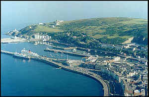
Douglas
Position: Lat 54 08.9N Lon 04 28.0W
Ramsey
Position: Lat 54 19.54N Lon 04 22.49W
Laxey
Position: Lat 54 19.54N Lon 04 22.49W
Peel
Position: Lat 54 13.6 N Lon 04 41.7 W
Port St. Mary
Position: Lat 54 04.4 N Lon 04 43.7 W
Castletown
Position: Lat 54 03.5 N Lon 04 38.6 W
Port Erin
Position: Lat 54 05.3 N Lon 04 46.3 W
DOUGLAS
Entry to the Harbour is gained from the N.E. (heading 229) by leading marks (white opposing triangles) which are illuminated at night by flashing (occ 10s) blue lights, now supplemented by red flashing opposing arrows. This approach will avoid possible overfalls at the end of the Breakwater The fairway is marked by 2 Starboard hand buoys (Q(3)G.5s) and (Fl.G3s) with, to Port, a concrete 'dolphin' (2F.red vert) which marks the end of the Breakwater. At the entrance, tides of up to 2 knots to the North East and South can be expected during flood and ebb tides respectively.
PEEL
Approach
Entry to the harbour is from the N to the NE. Care must be taken in strong NW'ly to NE'ly winds, which may cause heavy seas at the entrance. If approaching from the south, a good offing is recommended from the end of the breakwater, until the transit of the Groyne Beacon and the conspicuous power station chimney are in line 207o. At night, the leading line is marked by 2 synchronised Fl.R.5s lights. Entry is then between the breakwater and the Groyne Beacon. If berthing on the breakwater, the berths are to starboard. If continuing to the Inner Harbour, pass between Castle Jetty Occ.G.7s and the East Quay Pier Occ.R.7s to approach the swing bridge.
Marina Berths Peel
There are a small number of 12m and 10m marina berths available for visiting yachts and these will be allocated upon arrival. The berth will normally be communicated by VHF 12. The marina has power and water, and a facility block with showers and toilets. Access cards for the marina gates and facilities are available from the Harbour Office.
CASTLETOWN HARBOUR
On approach it is important to pass the red Can buoy (Fl.R 3s) which marks the Lheeah rio rocks, to port. The Breakwater Head lighthouse (white tower Red band Oc.R 15s) transit with the Irish Quay lighthouse (white tower red band Oc.R 4s) lead at approx. 323 degrees. It is advisable to pass to the North East of this transit to pass clear of a training wall from the Breakwater Head.
PORT ERIN
On approach it is important to pass the Green conical buoy marking the ruined breakwater to starboard which is uncovered at ½ ebb. At Night the leading lights 099 degrees (Front White tower with red band F.R.10m5M, Rear white column red band F.R.19m 5M) mark a course well to the north of the danger.
LAXEY HARBOUR
Berthing is limited because of the size of the harbour, but leisure craft can use the channel berths in favourable conditions. No deep water berths are available as the whole harbour dries at each low water. Seasonal mooring buoys are placed in Garwick Bay (1 mile south) over the summer period for visiting vessels.
PORT ST MARY
Approach from the SW it is advised to give Callow Point and Alfred Pier at least two cable clearance until the quay lighthouse is open to the North of the Alfred Pier. The Approach from the SE the transit of the two lighthouses (295 degrees) will take the vessel clear of the Carrick Rock (Q.2 5s)
Pilot Maps
Douglas Harbour
The main port of the Isle of Man with the most extensive facilities for both commercial and private vessels. Douglas is the only Manx port with dedicated passenger handling facilities and roll-on roll-off vehicle services. The port provides specialist berths for oil and gas tankers as well as general cargo vessels, fishing vessels and occasional survey, customs and naval vessels. The Isle of Man's first marina was opened during 2001 and offers a limited number of berths for visiting leisure craft, subject to availability. A second phase of pontoons was completed in the autumn of 2006. Substantial ongoing investment is continuing to further enhance the harbour's facilities. A private towage service is available and a commercial inshore passenger ferry operates various services throughout the summer season to other ports.
Peel Harbour
Traditionally a fishing port which used to annually host a huge herring fleet, Peel remains the most active fishing port on the Isle of Man but is also important commercially for the importation of various fuel oils. Situated on the west coast, Peel also has a comprehensive fish and shellfish processing industry and is home to the traditional art of kipper curing with guided tours organised for visitors throughout the curing season (May to September).
Peel's striking feature is its ancient castle overlooking the entrance to the inner harbour which also features the award-winning House of Manannan heritage centre, open all year round to visitors.
Ramsey Harbour
This is a well sheltered, tidal (+/- 2 ½ hours HW) port but access can be difficult in strong easterly winds as the entrance is via a narrow channel between 2 breakwaters. The harbour is busy with commercial vessels dealing with regular lo-lo services from the United Kingdom and Ireland and is the only Manx port with facilities to handle imports of bulk cement. The harbour, directly alongside the town centre, also has its own small shipyard, used mainly by local and visiting fishing vessels.
The disused Queen's Pier in Ramsey Bay was built in 1886 to provide a low water landing for passenger ferries and was last used in 1970. Debates continue on the various proposals currently being considered for its future.
Laxey Harbour
A small port on the east coast half way between Douglas and Ramsey. The harbour was built in the mid 1800s to service the lucraLaxey harbourtive mining industry but is now used by a small number of leisure craft and inshore fishing vessels. Laxey's traditional village has important Manx National Heritage sites which includes the giant waterwheel Lady Isabella - the world's largest working water wheel.
Berthing is limited because of the size of the harbour, but leisure craft can use the channel berths in favourable conditions. No deep water berths are available as the whole harbour dries at each low water. Seasonal mooring buoys are placed in Garwick Bay (1 mile south) over the summer period for visiting vessels.
Port Erin
Port Erin is a quiet seaside resort which can accommodate small craft and small inshore fishing vessels.
Regular cruising trips depart from here to the Calf of Man from Easter to late September. Port Erin is also known for its diving facilities.
Commercial activities centre on occasional cruise liners which anchor within the bay as weather conditions suit and land passengers by tender.
Port St Mary
Port St Mary is a classic small harbour in a beautiful setting.
It is popular with diving clubs with organised trips to dive sites. Fishing excursions also leave from Port St Mary during the tourist season. The harbour is used by fishing vessels, pleasure craft, occasional commercial coasters and passenger vessels.
Port St Mary consists of an inner drying harbour and an outer always afloat berthing harbour.
Castletown Harbour
Castletown is a heritage harbour consisting of outer and inner drying harbours. It is mainly used by inshore fishing vessels, local and visiting pleasure craft and occasional coasters.
Commercial limits cargo work is only accommodated in the inner harbour through a narrow swing bridge. The berth at the Umber Quay can accommodate vessels up to the maximum of 55M, beam 8.2M, and 3.5M draft MHWS 2.6 metres MHWN and those prepared to take the hard ground.
There is a lay-by berth on the Irish Quay with Maximum length 55M however there is no breadth restriction here. 3.8M on MHWS and 2.7M on MHWN.